Advertisements
Chapters
2: Population
3: Migration
4: Urbanization
5: Natural and Man-made Disasters with Case Studies
6: Disaster Management
7: Asia: Location, Extent, Political and Physical Features
8: Asia: Climate and Natural Vegetation
9: India: Location, Extent, Political and Physical Features
10: India: Climate, Natural Vegetation, Forests and Wildlife
11: Human Resources in India
![Oxford University Press solutions for Voyage Geography [English] Class 8 chapter 1 - Interpreting Topographical Maps - Shaalaa.com](/images/voyage-geography-english-class-8_6:8252e9b8eb0c48bba3b0177d4ba41329.jpg "Oxford University Press solutions for Voyage Geography [English] Class 8 chapter 1 - Interpreting Topographical Maps")
Advertisements
Solutions for Chapter 1: Interpreting Topographical Maps
Below listed, you can find solutions for Chapter 1 of CISCE Oxford University Press for Voyage Geography [English] Class 8.
Oxford University Press solutions for Voyage Geography [English] Class 8 1 Interpreting Topographical Maps Fill in the blanks
Fill in the blanks
A contour line is an imaginary line that connects all points having the same ______.
Fill in the blanks
In a grid system of a topo sheet, the lines that run vertically are called ______.
Fill in the blanks
Contour lines do not ______ one another.
Fill in the blanks
The contour lines of a hill are evenly spaced in the form of ______.
Fill in the blanks
Houses or huts in ______ settlement are far apart from one another.
Oxford University Press solutions for Voyage Geography [English] Class 8 1 Interpreting Topographical Maps Match the columns
| Column A | Column B | ||
| 1 | 45D/7 | a | To begin reading at topo sheet |
| 2 | South-west corner | b | Depression |
| 3 | Δ217 | c | topo sheet number |
| 4 | White portion in a topo sheet | d | Triangulated station |
| 5 | DEP | e | Barren land |
Oxford University Press solutions for Voyage Geography [English] Class 8 1 Interpreting Topographical Maps Choose the correct answer
Choose the correct answer
The contour lines for this feature are evenly spaced in the form of concentric circles.
conical hill
plateau
ridge
saddle
Choose the correct answer
The contours for this feature are oval with contours close to each other indicating steepness.
conical hill
plateau
ridge
saddle
Choose the correct answer
This feature can be identified by a drop in height of the contours.
conical hill
ridge
col
gap
Choose the correct answer
The green area in a topo sheet contains
settlement
barren land
cultivated land
vegetation
Choose the correct answer
On the topographical map these water bodies are shown in black colour.
Dry streams
Tank
Settlement
River
Oxford University Press solutions for Voyage Geography [English] Class 8 1 Interpreting Topographical Maps True or false
State whether the following are true or false
A contour line is an imaginary line that connects all points having the same temperature.
True
False
State whether the following are true or false
The lines that run vertically are called nothings.
True
False
State whether the following are true or false
Contour lines are drawn at fixed intervals.
True
False
State whether the following are true or false
A gap is a low lying depression or a valley which cuts through a range of hills.
True
False
State whether the following are true or false
The spot height is indicated on the map with a small triangle followed by the number.
True
False
Oxford University Press solutions for Voyage Geography [English] Class 8 1 Interpreting Topographical Maps Answer the following questions in brief
What do topographical maps show?
What is a contour line?
Distinguish Vertical Interval and Horizontal Equivalent.
What is a ridge?
How do you identify a ridge on a topo sheet?
What is a saddle?
Draw a diagram to show a saddle.
What is a linear settlement?
Where would you normally find a linear settlement?
How would you recognize a metalled road and an un metalled one on a topographical map?
Oxford University Press solutions for Voyage Geography [English] Class 8 1 Interpreting Topographical Maps Answer the following questions in one or two paragraphs
Answer the following questions in one or two paragraphs
What is a cliff?
Answer the following questions in one or two paragraphs
How can we identify a cliff on a toposheet?
Draw a diagram to show a cliff.
How is waterfall formed?
Draw a diagram to show a waterfall?
Where are V-shaped valleys and U-shaped valleys formed?
How can V-shaped valleys and U-shaped valleys be identified on a topo sheet?
What are the different factors that determine the location and the type of settlements?
How can transport and communication of an area be inferred directly from a topographical sheet?
Oxford University Press solutions for Voyage Geography [English] Class 8 1 Interpreting Topographical Maps Picture study
Picture study.

Identify the type of settlement shown in the picture.
Picture study.
Write two characteristics of this type of settlement.
Oxford University Press solutions for Voyage Geography [English] Class 8 1 Interpreting Topographical Maps Let’s Do Something
Identify the relief features shown by the following contour diagram
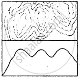
Identify the relief features shown by the following contour diagram

Identify the relief features shown by the following contour diagram
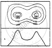
Identify the relief features shown by the following contour diagram
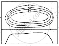
Identify the relief features shown by the following contour diagram
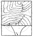
Identify the relief features shown by the following contour diagram

Oxford University Press solutions for Voyage Geography [English] Class 8 1 Interpreting Topographical Maps Extra Questions
What do you mean by eastings and northings in a topographical map?
Mention features of a grid system of a topo sheet.
Explain the two types of grid references.
Which is the most common method of showing relief or elevation on topo sheets?
List some basic characteristics of contour lines.
How are topo sheets prepared for India?
How would you identify the following on a topo sheet: Gentle slope and steep slope
How would you identify the following on a topo sheet: Plateau
How would you identify the following on a topo sheet: Hill
How would you identify the following on a topo sheet: Col
How would you identify the following on a topo sheet: Pass
How would you identify the following on a topo sheet: Gap
What do you mean by settlements?
Explain temporary settlements.
Explain permanent settlements.
What are the three main types of settlement patterns on a topo sheet?
Compare Nucleated settlement and scattered settlement.
List the aspects that you should keep in mind while studying a topographical map.
What do you mean by Vertical Interval (V.I.) in a topo sheet?
Mention what does the following indicate on a topographical map: Black stream
Mention what does the following indicate on a topographical map: Blue stream
Mention what does the following indicate on a topographical map: Green area
Mention what does the following indicate on a topographical map: Yellow area
Mention what does the following indicate on a topographical map: White area
Fill in the blanks
Eastings and northings cross each other to form a square known as a ______.
Fill in the blanks
When referring to a grid, ______ are always stated first.
Fill in the blanks
Using ______ is the most common method of showing relief or elevation on topo sheets.
Fill in the blanks
On a topographical map, every 5th line is drawn thick and known as the ______.
Fill in the blanks
If contour lines are drawn close together, it indicates ______ slope of the land and if they are drawn far apart, it indicates ______ slope.
Fill in the blanks
______ are groups of houses where people live, such as villages or towns.
Fill in the blanks
Tents and huts are the most common forms of shelter in ______ settlements.
Fill in the blanks
______ settlement indicates that the large community is close knit and living on a fertile land.
Fill in the blanks
______ settlement develop in a line on either side of a road or a railway track.
Fill in the blanks
______ settlement is indicated by long distances between houses on map.
Fill in the blanks
______ are indicated on the topo sheet with a small triangle followed by the number.
Fill in the blanks
Settlements are always shown by ______ squares.
Fill in the blanks
The grid on the ______ corner of a topographical map is always the reference point or the starting point.
Solutions for 1: Interpreting Topographical Maps
Oxford University Press solutions for Voyage Geography [English] Class 8 chapter 1 - Interpreting Topographical Maps
Shaalaa.com has the CISCE Mathematics Voyage Geography [English] Class 8 CISCE solutions in a manner that help students grasp basic concepts better and faster. The detailed, step-by-step solutions will help you understand the concepts better and clarify any confusion. Oxford University Press solutions for Mathematics Voyage Geography [English] Class 8 CISCE 1 (Interpreting Topographical Maps) include all questions with answers and detailed explanations. This will clear students' doubts about questions and improve their application skills while preparing for board exams.
Further, we at Shaalaa.com provide such solutions so students can prepare for written exams. Oxford University Press textbook solutions can be a core help for self-study and provide excellent self-help guidance for students.
Concepts covered in Voyage Geography [English] Class 8 chapter 1 Interpreting Topographical Maps are On the Basis of Topographical Sheet, Interpret Contours on the Sheet (Height, Shape), Identify Landforms Through Contours, Patterns of Settlement.
Using Oxford University Press Voyage Geography [English] Class 8 solutions Interpreting Topographical Maps exercise by students is an easy way to prepare for the exams, as they involve solutions arranged chapter-wise and also page-wise. The questions involved in Oxford University Press Solutions are essential questions that can be asked in the final exam. Maximum CISCE Voyage Geography [English] Class 8 students prefer Oxford University Press Textbook Solutions to score more in exams.
Get the free view of Chapter 1, Interpreting Topographical Maps Voyage Geography [English] Class 8 additional questions for Mathematics Voyage Geography [English] Class 8 CISCE, and you can use Shaalaa.com to keep it handy for your exam preparation.
