ISC (Arts)
Academic Year: 2022-2023
Date & Time: 17th February 2023, 2:00 pm
Duration: 3h
Advertisements
- Candidates are allowed additional 15 minutes for only reading the paper.
- They must NOT start writing during this time.
- Answer all questions in Section A, Section B and Section C.
- Section A consists of objective short-answer questions.
- Section B consists of short answer questions.
- Section C consists of long answer questions.
- The intended marks for questions or parts of questions are given in brackets [].
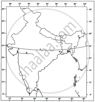
Refer to the outline Map of India provided and answer the following questions on the Map:

- Mark and label the following on the given map of India.
- The coastal plain that receives rainfall from Northeast monsoons.
- The oldest mountain range of India.
- The plateau rich in minerals in India.
- The angular value of the latitude marked L is ______.
- 37°4' N
- 68°7' N
- 8°4' N
- 23°30' N
- The riverine port marked P is ______.
- Kolkata
- Kochi
- Vishakhapatnam
- Chennai
- The cotton textile centre marked by the Δ is ______.
- Mumbai
- Coimbatore
- Pune
- Ahmedabad
- The state marked E has the highest ______.
- literacy rate.
- index of concentration of population.
- density of population
- level of urbanisation.
- Identify the following:
- The city marked T, which is one of the terminals of the North-South corridor, is ______.
- The oldest oilfield of India marked C is ______.
- The west flowing river marked R between the Vindhyas and the Satpura range is ______.
Chapter: [0.012] Structure of India
The main Standard geological era is ______.
Dravidian
Archean
Pre Cambrian
Aryan
Chapter: [0.012] Structure of India
The only perennial river of South India is ______.
Godavari
Krishna
Kaveri
Narmada
Chapter: [0.033] Water Resources and Types of Irrigation
According to the Government of India Census of 2011, the state with the highest density of population is ______.
Chapter: [0.022000000000000002] National and State Level Patterns of Population Distribution
River Brahmaputra is a tributary of River Ganga.
True
False
Chapter: [0.012] Structure of India
Differentiate between the national migration and international migration. Give an example of each type.
Chapter: [0.024] Migration Trends Over the Last 25 Years
Briefly discuss any two factors that affect the types of rural settlements.
Chapter: [0.026000000000000002] Rural settlements
Explain any two reasons for migration of people from rural to urban areas.
Chapter: [0.024] Migration Trends Over the Last 25 Years
Briefly discuss the implications of non-working population on the country's development.
Chapter: [0.025] Demographic attributes at National level
Advertisements
A farmer in Tamil Nadu produces three crops of rice in an agricultural year.
What kind of a land use pattern is being referred to?
Chapter: [0.032] Land Resources
A farmer in Tamil Nadu produces three crops of rice in an agricultural year.
Why is the farmer able to cultivate three crops in a year?
Chapter: [0.034] Agriculture: Types, Development and Problems
A farmer in Tamil Nadu produces three crops of rice in an agricultural year.
Mention any two reasons for less percentage of this type of land in India.
Chapter: [0.032] Land Resources
What is rainwater harvesting?
Chapter: [0.033] Water Resources and Types of Irrigation
Briefly discuss why rainwater harvesting is considered an important method of conserving water.
Chapter: [0.033] Water Resources and Types of Irrigation
State any two advantages of hydel power over thermal power.
Chapter: [0.036000000000000004] Sources of Energy
Mention any two characteristics features of the Himalayas.
Chapter: [0.012] Structure of India
State any two uses of manganese.
Chapter: [0.036000000000000004] Sources of Energy
Briefly explain the geological evolution of the Himalayas.
Chapter: [0.012] Structure of India
Discuss any four changes brought by satellites in the field of communication in India.
Chapter: [0.042] Communication – Importance of Communication in Rural Development and Its Policy. Importance of Infrastructure as Key to the Development of an Industrial Economy.
Advertisements
What is meant by animal husbandry?
Chapter: [0.034] Agriculture: Types, Development and Problems
Briefly discuss why animal husbandry is important in Indian agriculture.
Chapter: [0.034] Agriculture: Types, Development and Problems
Explain urban area according to Government of India Census of 2011.
Chapter: [0.022000000000000002] National and State Level Patterns of Population Distribution
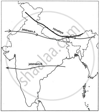
Study the sketch map given below and answer the questions that follow:

- State the direction of the movement of the jetstreams A and B in the Indian region. Give reasons for the same.
- How do the jetstreams A and B influence the Indian climate?
Chapter: [0.012] Structure of India
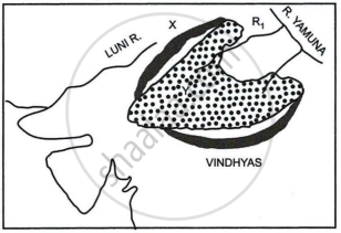
Study the sketch map given below and answer the questions that follow:

- Identify the dotted region marked Y. Mention any three of its characteristic features.
- Name the mountain range marked X, the river marked R1 and the type of rock that constitutes the dotted region.
Chapter: [0.012] Structure of India
Explain the difference between a mesa-region and a micro-region with the help of an example of each.
Chapter: [0.06] Regional Economic Development
State any three factors that have led to the growth of Haldia as an important port city.
Chapter: [0.06] Regional Economic Development
Which is the main oilseed of India?
Chapter: [0.034] Agriculture: Types, Development and Problems
Briefly explain any three conditions necessary for groundnut growth.
Chapter: [0.034] Agriculture: Types, Development and Problems
State a difference between wet farming and dry farming. Give an example of each.
Chapter: [0.034] Agriculture: Types, Development and Problems
Read the passage given below and answer the questions that follow:
| Alice, a seventeen-year-old girl visited a hill station for its natural and scenic beauty. However, she found that the hill station was crowded, with hotels and resorts. The lakes were polluted with plastic bags and bottles. She approached the local authorities to spread awareness on the need to protect the environment and restore the natural beauty of the place. |
- Suggest any one measure that can help Alice in her initiative.
- Give any two points on the need to develop ecotourism in India.
- Explain any four problems of tourism in India.
Chapter: [0.054000000000000006] Tourism Industry
Submit Question Paper
Help us maintain new question papers on Shaalaa.com, so we can continue to help studentsonly jpg, png and pdf files
CISCE previous year question papers Class 12 Geography with solutions 2022 - 2023
Previous year Question paper for CISCE Class 12 -2023 is solved by experts. Solved question papers gives you the chance to check yourself after your mock test.
By referring the question paper Solutions for Geography, you can scale your preparation level and work on your weak areas. It will also help the candidates in developing the time-management skills. Practice makes perfect, and there is no better way to practice than to attempt previous year question paper solutions of CISCE Class 12.
How CISCE Class 12 Question Paper solutions Help Students ?
• Question paper solutions for Geography will helps students to prepare for exam.
• Question paper with answer will boost students confidence in exam time and also give you an idea About the important questions and topics to be prepared for the board exam.
• For finding solution of question papers no need to refer so multiple sources like textbook or guides.
