Advertisements
Advertisements
Question
How do the contour lines show the direction of the flow of rivers and streams?
Solution
A V-shaped cross-section of a river valley occurs when the two sides are close and steep, with little level terrain in between. They occur in the upper reaches of a river.
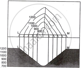
The contour lines of this type of Valley are in inverted V-shape, decreasing inward. The section shows a V-shaped landform.
APPEARS IN
RELATED QUESTIONS
Mention the important features of a river valley.
Show the different drainage patterns.
What are Bench Marks?
What are contours?
What does the spacing of contours indicate?
Write a short note on Contours.
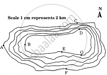
Study the contour pattern and answer the following questions.
- Name the geographical feature formed by contours.
- Find out the contour interval in the map.
- Find out the map distance between E and F and convert it into the ground distance.
- Name the type of slope between A and B; C and D and E and F.
- Find out the direction of E, D, and F from G.
Give the term used in contour for the following:
The numerical difference between two contour lines.
What do the contour lines represent?
