Advertisements
Advertisements
Questions
What are contours?
What is a 'contour'?
Solution 1
Contours are imaginary lines joining places having the same elevation above mean sea level. In other words, these are imaginary lines joining all the points of equal elevation or altitude above mean sea level. They are also called “level lines”. A map showing the landform of an area by contours is called a contour map. The method of showing relief features through contour is very useful and versatile. The contour lines on a map provide a useful insight into the topography of an area.
Solution 2
The imaginary lines drawn on a map join places having the same height above the sea level.
RELATED QUESTIONS
Mention the important features of a river valley.
Show the different drainage patterns.
What are Bench Marks?
What does the spacing of contours indicate?
Write a short note on Contours.
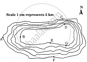
Study the contour pattern and answer the following questions.
- Name the geographical feature formed by contours.
- Find out the contour interval in the map.
- Find out the map distance between E and F and convert it into the ground distance.
- Name the type of slope between A and B; C and D and E and F.
- Find out the direction of E, D, and F from G.
Give the term used in contour for the following:
The numerical difference between two contour lines.
What do the contour lines represent?
How do the contour lines show the direction of the flow of rivers and streams?
