Advertisements
Advertisements
Question
What is the Inter-Tropical Convergence Zone?
Solution
The Inter-Tropical Convergence Zone (ITCZ) is a low-pressure zone located at the equator where trade winds converge, and so, it is a zone where air tends to ascend. In July, the ITCZ has located around 20° N-25° N latitudes (over the Gangetic plain). These are sometimes called the monsoon trough. This monsoon trough encourages the development of thermal low over north and northwest India. Due to the shift of ITCZ, the trade winds of the southern hemisphere cross the equator between 40° and 60° E longitudes and start blowing from southwest to northeast due to the Coriolis force. It becomes southwest monsoon. In winter, the ITCZ moves southward, and so the reversal of winds from northeast to south and southwest takes place. They are called northeast monsoons.
APPEARS IN
RELATED QUESTIONS
Give two important characteristics of the South West monsoon rainfall.
The northern plains of India do not freeze in winter.
Kochi has a lesser annual range of temperature than Agra.
Study the temperature and rainfall graph of station X given below and answer the questions that follow :
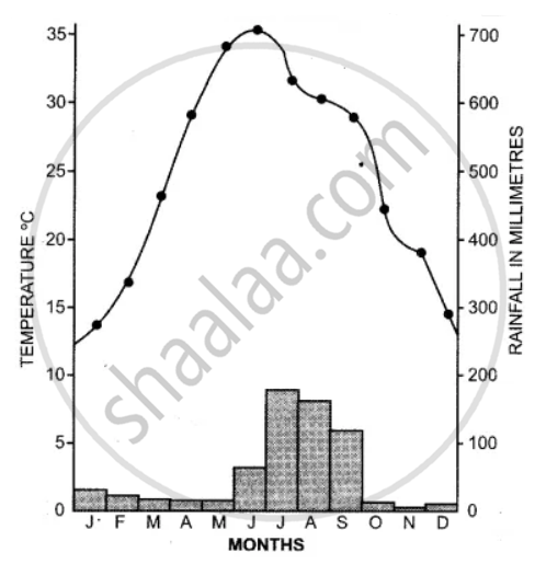
(i) Is the location of station X inland or coastal?
(ii) What is the cause of a sudden fall of temperature in July, even though it is a summer month?
(iii) Mention one main feature of the climate experienced by the station X.
Study the climatic data provided in the table below for a city A in India and answer the questions that follow :
| City | T/R | J | F | M | A | M | J | J | A | S | O | N | D |
| A | T | -8 | -3 | 2 | 7 | 15 | 18 | 17 | 12 | 10 | 5 | 0 | -7 |
| R | 10 | 8 | 8 | 5 | 5 | 5 | 13 | 13 | 8 | 5 | 0 | 5 |
T = Mean monthly temperature in degree Celsius (°C).
R = Average monthly rainfall in millimeters (mm).
(i) What is the cause of low rainfall in station A?
(ii) Calculate the range of temperature of this station.
Explain how the following factor affect India’s climate :
Southern Oscillation
Answer the following question.
What are the two climatic conditions required for the cultivation of ground-nuts in India?
Answer the following question.
Mention the climatic conditions required for growing coconut in India.
Name the month when the highest amount of rainfall is received.
Continental climate is experienced by ______.
In the upper layers of the troposphere ______ are found.
The unifying factor of the climate of India is ______ winds.
Retreating monsoon winds flow from ______.
The mountain which stands parallel to the direction of the south-west monsoon wind.
What is meant by 'normal lapse rate'?
What are ‘jet streams’?
Write a short note on ‘Monsoon wind’.
Name the areas which receive heavy rainfall.
Mountains are cooler than the plains.
Retreating monsoon winds flow from ______.
Which are the regions that receive heavy rainfall and flood prone in India?
Name the factors determining the climate of India.
Name the factors affecting the climate of India.
What are the major determinants of the climate of a place? Explain them.
What are the three important factors which influence the mechanism of Indian weather?
Find out the temperature of Ooty (2240m) when it is 35°C in Chennai (6.7m)
