Topics
India — Location
- Introduction to India - Location
- Size of India
- India and Its Neighbours
Geography as a Discipline
- Introduction to Geography as a Discipline
- Geography as an Integrating Discipline
- Branches of Geography
Introduction to Maps
- Essentials of Map Making
- History of Map Making
- Types of Maps Based on Scale
- Types of Maps Based on Function
- Uses of Maps
India Physical Environment
The Origin and Evolution of the Earth
- Introduction to the Origin and Evolution of the Earth
- Early Theories
- Modern Theories
- Our Solar System
- The Moon
- Evolution of the Earth
Fundamentals of Physical Geography
Map Scale
- Methods of Scale
- Conversion of Scale
- Construction of the Graphical/Bar Scale
Structure and Physiography
- Introduction to Structure and Physiography
- The Peninsular Block
- The Himalayas and Other Peninsular Mountains
- Indo-Ganga-Brahmaputra Plain
- Physical Divisions of India
- The North and Northeastern Mountains
- North Indian Plains
- The Peninsular Indian Plateau
- The Indian Desert
- The Indian Coastal Plains
- The Indian Islands
Interior of the Earth
- Interior of the Earth
- Sources of Information About the Interior
- Earthquake
- Structure of the Earth
- Volcanoes and Volcanic Landforms
Practical Work in Geography
Drainage System
- Introduction to Drainage System
- Drainage Systems of India
- Himalayan Rivers
- Peninsular Rivers
- River Regimes
- Extent of Usability of River Water
Latitude, Longitude and Time
- Introduction to Latitude, Longitude and Time
- Parallels of Latitudes
- Meridians of Longitude
- Longitude and Time
- International Date Line
Map Projections
- Need for Map Projection
- Elements of Map Projection
- Classification of Map Projections
- Constructing Some Selected Projections
Climate
- Introduction to Climate
- Unity and Diversity in the Monsoon Climate
- Factors Affecting the Indian Climate
- The Nature of Indian Monsoon
- The Rhythm of Seasons
- The Cold Weather Season
- The Hot Weather Season
- The Southwest Monsoon Season
- Season of Retreating Monsoon
- Traditional Indian Seasons
- Global Warming
Distribution of Oceans and Continents
- Introduction to Distribution of Oceans and Continents
- Continental Drift
- Concept of Sea Floor Spreading
- Plate Tectonics
- Movement of the Indian Plate
Minerals and Rocks
- Rocks and Minerals
- Minerals
- Rocks
- Rock Cycle
Topographical Maps
- Introduction to Topographical Maps
- Methods of Relief Representation
- Contour
- Types of Slope
- Types of Landforms
- Valley
- Identification of Cultural Features from Topographical Sheets
- Topographic or Ordnance Survey Maps
- Map Interpretation Procedure
Natural Vegetation
- Natural Vegetation
- Types of Forests
- Forest Cover in India
- Forest Conservation
- Wildlife
- Wildlife Conservation in India
- Biosphere Reserve
Soils
- Introduction to Soils
- Types of Soil
- Soil Degradation
- Soil Erosion
- Soil Conservation
Geomorphic Processes
- Geomorphic Processes
- Endogenic Processes
- Exogenic Processes
- Weathering
- Mass Movements
- Erosion and Deposition
- Soil Formation
Introduction to Aerial Photographs
- Introduction to Aerial Photographs
- Uses of Aerial Photographs
- Advantages of Aerial Photography
- Types of Aerial Photographs
- Geometry of an Aerial Photograph
- Difference Between a Map and an Aerial Photograph
- Scale of Aerial Photograph
Introduction to Remote Sensing
- Introduction to Remote Sensing
- Stages in Remote Sensing
- Sensors
- Resolving Powers of the Satellites
- Sensor Resolutions
- Data Products
- Interpretation of Satellite Imageries
Landforms and Their Evolution
- Introduction to Landforms and Their Evolution
- Running Water
- Groundwater
- Glaciers
- Waves and Currents
- High Rocky Coasts
- Low Sedimentary Coasts
- Winds
Natural Hazards and Disasters
- Introduction to Natural Hazards and Disasters
- Classification of Natural Disasters
- Natural Disasters and Hazards in India
- Earthquakes
- Tsunami
- Tropical Cyclone
- Floods
- Droughts
- Landslides
- Disaster Management
Weather Instruments, Maps and Charts
- Introduction to Weather Instruments, Maps and Charts
- Weather Observations
- Surface Observatories
- Space-based Observations
- Weather Instruments
- Weather Maps and Charts
- Weather Symbols
Composition and Structure of Atmosphere
- Introduction to Composition and Structure of Atmosphere
- Composition of the Atmosphere
- Atmosphere and Its Layers
Solar Radiation, Heat Balance and Temperature
- Introduction to Solar Radiation, Heat Balance and Temperature
- Solar Radiation
- Heating and Cooling of Atmosphere
- Inversion of Temperature
Atmospheric Circulation and Weather Systems
- Introduction to Atmospheric Circulation and Weather Systems
- Atmospheric Pressure
- Forces Affecting the Velocity and Direction of Wind
- General Circulation of the Atmosphere
Water in the Atmosphere
- Introduction of Water in the Atmosphere
- Evaporation and Condensation
- Rainfall and It's Types
- World Distribution of Rainfall
World Climate and Climate Change
- Introduction of World Climate and Climate Change
- Koeppen’s Scheme of Classification of Climate
- Group A : Tropical Humid Climates
- Dry Climates : B
- Cold Snow Forest Climates (D)
- Polar Climates (E)
- Highland Climates (H)
- Climate Change
- Causes of Climate Change
- Global Warming
- Greenhouse Effect and Global Warming
Water (Oceans)
- Hydrologic Cycle Or Water Cycle
- Components of Hydrologic Cycle
- The Relief of Ocean Floor
- Temperature of Ocean Waters
- Salinity of Ocean Waters
Movements of Ocean Water
- Introduction to Movements of Ocean Water
- Waves in Ocean Water
- Tides
- Types of Tides
- Ocean Currents
Life on the Earth
- Introduction to Life on the Earth
- Ecology
- Types of Ecosystems
- Biogeochemical Cycle
- Ecological Balance
Biodiversity and Conservation
- Introduction to Biodiversity and Conservation
- Levels of Biodiversity
- Importance of Biodiversity
- Loss of Biodiversity
- Conservation of Biodiversity
- Atmosphere
- Layers of Atmosphere
- The Role of Atmosphere In Climate Control
Atmosphere:
The envelope of air around the Earth is called the atmosphere. It is composed of nitrogen, oxygen, water vapour, and carbon dioxide, with other gases present in small quantities. The atmosphere is like a protective blanket that keeps our planet safe and helps support life.
Layers of Atmosphere:
- Troposphere: The troposphere, the closest layer to Earth's surface, is where we live and weather occurs. It is 8 to 15 kilometres thick and contains air, clouds, rain, snow, and storms. As we rise, the troposphere becomes colder. It is primarily composed of nitrogen and oxygen.
- Stratosphere: The stratosphere, located 15 to 50 kilometres above the Earth's surface, is crucial as it contains the ozone layer, which absorbs most of the sun's harmful UV rays. As you rise, the stratosphere becomes warmer due to the ozone absorbing the sun's energy.
- Mesosphere: The mesosphere, located 50-85 kilometres above Earth, is the layer where most meteors burn up, creating shooting stars. It is also the coldest layer, with temperatures dropping as low as -90°C (-130°F).
- Thermosphere: The thermosphere, extending from 85 to 600 kilometres above Earth, is characterised by thin air and extreme temperatures up to 2,500 °C due to the sun's intense energy. This layer is where auroras occur and the International Space Station orbits.
- Exosphere: The exosphere, the outermost layer of the atmosphere, extends from Earth's surface to space and is thin with few air molecules. Satellites orbit this layer, which gradually fades into outer space.
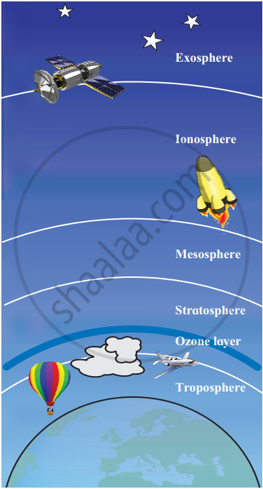
Layers of Atmosphere
The Role of Atmosphere In Climate Control:
- The atmosphere keeps the average temperature of the Earth fairly steady during the day and even during the whole year.
- The atmosphere prevents a sudden increase in temperature during daylight hours and slows down the escape of heat into outer space at night.
- The moon, which is almost the same distance from the sun as the Earth, has a temperature range of about -190°C to 110°C and no atmosphere.
If you would like to contribute notes or other learning material, please submit them using the button below.
