Topics
India — Location
- Introduction to India - Location
- Size of India
- India and Its Neighbours
Geography as a Discipline
- Introduction to Geography as a Discipline
- Geography as an Integrating Discipline
- Branches of Geography
Introduction to Maps
- Essentials of Map Making
- History of Map Making
- Types of Maps Based on Scale
- Types of Maps Based on Function
- Uses of Maps
India Physical Environment
The Origin and Evolution of the Earth
- Introduction to the Origin and Evolution of the Earth
- Early Theories
- Modern Theories
- Our Solar System
- The Moon
- Evolution of the Earth
Fundamentals of Physical Geography
Map Scale
- Methods of Scale
- Conversion of Scale
- Construction of the Graphical/Bar Scale
Structure and Physiography
- Introduction to Structure and Physiography
- The Peninsular Block
- The Himalayas and Other Peninsular Mountains
- Indo-Ganga-Brahmaputra Plain
- Physical Divisions of India
- The North and Northeastern Mountains
- North Indian Plains
- The Peninsular Indian Plateau
- The Indian Desert
- The Indian Coastal Plains
- The Indian Islands
Interior of the Earth
- Interior of the Earth
- Sources of Information About the Interior
- Earthquake
- Structure of the Earth
- Volcanoes and Volcanic Landforms
Practical Work in Geography
Drainage System
- Introduction to Drainage System
- Drainage Systems of India
- Himalayan Rivers
- Peninsular Rivers
- River Regimes
- Extent of Usability of River Water
Latitude, Longitude and Time
- Introduction to Latitude, Longitude and Time
- Parallels of Latitudes
- Meridians of Longitude
- Longitude and Time
- International Date Line
Map Projections
- Need for Map Projection
- Elements of Map Projection
- Classification of Map Projections
- Constructing Some Selected Projections
Climate
- Introduction to Climate
- Unity and Diversity in the Monsoon Climate
- Factors Affecting the Indian Climate
- The Nature of Indian Monsoon
- The Rhythm of Seasons
- The Cold Weather Season
- The Hot Weather Season
- The Southwest Monsoon Season
- Season of Retreating Monsoon
- Traditional Indian Seasons
- Global Warming
Distribution of Oceans and Continents
- Introduction to Distribution of Oceans and Continents
- Continental Drift
- Concept of Sea Floor Spreading
- Plate Tectonics
- Movement of the Indian Plate
Minerals and Rocks
- Rocks and Minerals
- Minerals
- Rocks
- Rock Cycle
Topographical Maps
- Introduction to Topographical Maps
- Methods of Relief Representation
- Contour
- Types of Slope
- Types of Landforms
- Valley
- Identification of Cultural Features from Topographical Sheets
- Topographic or Ordnance Survey Maps
- Map Interpretation Procedure
Natural Vegetation
- Natural Vegetation
- Types of Forests
- Forest Cover in India
- Forest Conservation
- Wildlife
- Wildlife Conservation in India
- Biosphere Reserve
Soils
- Introduction to Soils
- Types of Soil
- Soil Degradation
- Soil Erosion
- Soil Conservation
Geomorphic Processes
- Geomorphic Processes
- Endogenic Processes
- Exogenic Processes
- Weathering
- Mass Movements
- Erosion and Deposition
- Soil Formation
Introduction to Aerial Photographs
- Introduction to Aerial Photographs
- Uses of Aerial Photographs
- Advantages of Aerial Photography
- Types of Aerial Photographs
- Geometry of an Aerial Photograph
- Difference Between a Map and an Aerial Photograph
- Scale of Aerial Photograph
Introduction to Remote Sensing
- Introduction to Remote Sensing
- Stages in Remote Sensing
- Sensors
- Resolving Powers of the Satellites
- Sensor Resolutions
- Data Products
- Interpretation of Satellite Imageries
Landforms and Their Evolution
- Introduction to Landforms and Their Evolution
- Running Water
- Groundwater
- Glaciers
- Waves and Currents
- High Rocky Coasts
- Low Sedimentary Coasts
- Winds
Natural Hazards and Disasters
- Introduction to Natural Hazards and Disasters
- Classification of Natural Disasters
- Natural Disasters and Hazards in India
- Earthquakes
- Tsunami
- Tropical Cyclone
- Floods
- Droughts
- Landslides
- Disaster Management
Weather Instruments, Maps and Charts
- Introduction to Weather Instruments, Maps and Charts
- Weather Observations
- Surface Observatories
- Space-based Observations
- Weather Instruments
- Weather Maps and Charts
- Weather Symbols
Composition and Structure of Atmosphere
- Introduction to Composition and Structure of Atmosphere
- Composition of the Atmosphere
- Atmosphere and Its Layers
Solar Radiation, Heat Balance and Temperature
- Introduction to Solar Radiation, Heat Balance and Temperature
- Solar Radiation
- Heating and Cooling of Atmosphere
- Inversion of Temperature
Atmospheric Circulation and Weather Systems
- Introduction to Atmospheric Circulation and Weather Systems
- Atmospheric Pressure
- Forces Affecting the Velocity and Direction of Wind
- General Circulation of the Atmosphere
Water in the Atmosphere
- Introduction of Water in the Atmosphere
- Evaporation and Condensation
- Rainfall and It's Types
- World Distribution of Rainfall
World Climate and Climate Change
- Introduction of World Climate and Climate Change
- Koeppen’s Scheme of Classification of Climate
- Group A : Tropical Humid Climates
- Dry Climates : B
- Cold Snow Forest Climates (D)
- Polar Climates (E)
- Highland Climates (H)
- Climate Change
- Causes of Climate Change
- Global Warming
- Greenhouse Effect and Global Warming
Water (Oceans)
- Hydrologic Cycle Or Water Cycle
- Components of Hydrologic Cycle
- The Relief of Ocean Floor
- Temperature of Ocean Waters
- Salinity of Ocean Waters
Movements of Ocean Water
- Introduction to Movements of Ocean Water
- Waves in Ocean Water
- Tides
- Types of Tides
- Ocean Currents
Life on the Earth
- Introduction to Life on the Earth
- Ecology
- Types of Ecosystems
- Biogeochemical Cycle
- Ecological Balance
Biodiversity and Conservation
- Introduction to Biodiversity and Conservation
- Levels of Biodiversity
- Importance of Biodiversity
- Loss of Biodiversity
- Conservation of Biodiversity
- Introduction
- Types of Biogeochemical Cycle
Introduction:
The biogeochemical cycle refers to the continuous movement of nutrients within an ecosystem between the abiotic (non-living) and biotic (living) components. Unlike the one-way flow of energy, nutrients are recycled in a circular process that ensures their availability for the growth of organisms.
Nutrients, such as carbon, nitrogen, and phosphorus, move between the lithosphere (land), atmosphere (air), and hydrosphere (water), which together form the biosphere. These nutrients are absorbed by plants from the soil, air, or water, then transferred to animals and other organisms through food chains. When plants and animals die or release waste, decomposers break down the organic matter, returning nutrients back to the abiotic environment.
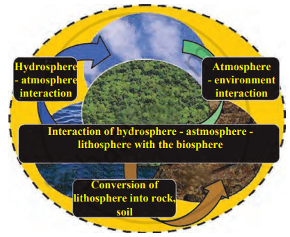
Biogeochemical cycle
This cyclical process ensures a continuous supply of essential nutrients and is driven by energy transfer in the ecosystem. It is a vital system that maintains balance and supports the sustainability of life on Earth.
There are four main biogeochemical cycles
- The Water Cycle
- The Nitrogen Cycle
- The Carbon Cycle
- The Oxygen Cycle
Types of Biogeochemical Cycle:
| Gaseous Cycle | Sedimentary Cycle |
| It is found in the Earth's atmosphere. | It is found in soil, sediment, and sedimentary rocks. |
| It includes nitrogen, oxygen, carbon dioxide, and water vapour. | It includes soil components like iron, calcium, and phosphorus. |
| Faster cycle due to processes like wind dispersal and plant absorption. | Slower cycle due to the involvement of geological processes. |
| Affected by activities like deforestation, pollution, and industrial emissions. | Affected by mining, soil erosion, and land use changes. |
| It is rapidly influenced by climate change. | It is gradually influenced by long-term climatic and geological changes. |
Related QuestionsVIEW ALL [16]
Complete the following table (Carefully study the carbon, oxygen, and nitrogen cycles).
| Bio-geo-chemical cycles | Biotic processes | Abiotic processes |
| 1. Carbon cycle | ||
| 2. Oxygen cycle | ||
| 3. Nitrogen cycle |
