Topics
Field Visit
Location and Extent
Physiography and Drainage
- Physical Divisions of India
- The North Indian Mountains
- The Himalayas
- North Indian Plains
- The Peninsular Indian Plateau
- The Indian Coastal Plains
- The Indian Islands
- Physiography of Brazil
- Brazilian Highlands
- The Great Escarpment in Brazil
- Coastline of Brazil
- Brazilian Plains
- Brazilian Island
- Drainage of Brazil
- Drainage Systems of India
- Himalayan Rivers
- Peninsular Rivers
Climate
Natural Vegetation and Wildlife
Population
Human Settlements
Economy and Occupations
Tourism, Transport and Communication
Geography - Physical Divisions of India
Identification of Physical divisions
- Identification of Physical Divisions
Geography - North Indian Mountains
Himalayas
Associated mountains
- Concept of Associated Mountains
Geography - North Indian Plain Region
Deserts
- Desert
Western Plains
- Concept of Western Plains
Central Plains
- Concept on Central Plains
Delta region
- Concept of Delta Region
Eastern Plains
- Concept of Eastern Plains
Geography - Peninsular Plateau Region
Chhotta Nagpur Plateau
- Concept for Chhotta Nagpur Plateau
Malwa Plateau
- Concept on Malwa Plateau
Maharashtra Plateau
- Concept for Maharashtra Plateau
Karnataka Plateau
- Concept for Karnataka Plateau
Telangana Plateau
- Concept for Telangana Plateau
Geography - Western Ghats and Eastern Ghats
Eastern Ghats
- Concept on Eastern Ghats
Sahyadries
- Concept on Sahyadries
Geography - Coastal Region
- Geography - Coastal Region
Eastern coastal plain
- Coastal Region - Eastern Coastal Plain
- Concept for Western Coastal Plain
Western coastal plain
- Concept for Western Coastal Plain
Geography - Indian Islands
- Geography - Indian Islands
Eastern Islands
- Indian Islands - Eastern Islands
Western Islands
- Indian Islands - Western Islands
Geography - Practical 1
Cartography
- Concept on Cartography
Geography - Practical 2
Two dimensional diagrams
- Two Dimensional Shapes
One dimensional diagrams
- Concept on One Dimensional Diagrams
Economics - Introduction of an Economy
Introduction of an Economy
- Economy
- Types of Economy
- Main Features of Economy
Economics - Basic problems of an economy solution
Solutions
- Concept for Capitalism
- Concept for Socialism
- Mixed Economy
Problems
- Introduction of Basic Problems of an Economy
- Problems- for Whom to Produce
- Problem - How Much to Produce
- Problem - by Whom to Produce
Economics - Inflation
Introduction
- Introduction of Inflation
Effects of inflation
- Effects of Inflation
Measures of Inflation
- Measures of Inflation
Causes of inflation
- Causes of Inflation
Economics - Public distribution system and consumer protection
- Measures of Inflation
Public Distribution system - meaning and explanation
- Public Distribution System - Meaning and Explanation
Introduction
- Introduction of Public Distribution System and Consumer Protection
Objectives of Public Distribution system
- Objectives of Public Distribution System
Remedial Measures
- Remedial Measures Public Distribution System and Consumer Protection
Consumer Protection
- Consumer Protection - Rights and Duties of Cunsumer, Food Adulteration
Drawbacks of Public Distribution system
- Drawbacks of Public Distribution System
Progress of Public Distribution system
- Progress of Public Distribution System
Definition
- Peninsula: A peninsula is defined as a piece of land bordered by water on three of its sides.
- Plateau: An area of fairly level high ground.
Notes
The Peninsular Plateaus:
|
The Peninsular plateau of India |

- The Great Northern Plains are to the south of the plateau area.
- This is our country's largest physiographic division.
- Half of the country's total area, or 16 lakh square kilometres, is covered by it.
-
It is an ancient, rocky, plateau area.
-
The terrain is made up of plateaus and hill ranges interspersed with river valleys.
- The plateau region's northern-western boundary is marked by the Aravalli Hills.
- The Bundelkhand upland, Kaimur, and Rajmahal hills serve as its northern and north-eastern limits.
- The Western Ghats and the Eastern Ghats, respectively, serve as the western and eastern frontiers.
- A sizable chunk of the plateau is more than 600 metres above mean sea level. The plateau's highest point is the peak of Anaimudi. It lies in Anaimalai and is 2,695 metres tall.
- This plateau slopes mostly in the direction of the east.
- The extremely old continental mass known as Gondwana includes the Great Plateau. Old age caused the rivers in this area to reach their base level and form large, shallow valleys.
- The Indian plateau is split roughly in half by the Narmada River. The region lying to the north of the Narmada is called the Central Highlands and the region lying to the south of Narmada is called the Deccan Plateau.
- The majority of the rivers, including the Mahanadi, Godavari, Krishna, and Kaveri, which run into the Bay of Bengal to the east of the Vindhya Mountains.
- The two rivers located south of the Vindhyas' westward flow are Narmada and Tapti. Due to the presence of a rift valley in the area, they are moving toward the west.
A) Central Highlands:
- Between the Narmada River and the Northern Great Plains are the Central Highlands.
- The Central Highlands are bordered on the west and northwest by the Aravallis. These hills reach Delhi from Gujarat through Rajasthan in a northwesterly direction of around 700 km. These hills in the southwest are about 1,500 m tall, compared to only 400 m in the area close to Delhi.
- With 1,722 metres, Gurushikhar is the highest mountain in this range.
- The Western part of the Central Highland is known as the Malwa Plateau.
- It is situated north of the Vindhyachal Range and southeast of the Aravallis. The Malwa Plateau is drained by the rivers Chambal, Betwa, and Ken before they merge with the Yamuna.
- Bundelkhand and Bagelkhand are the names for the portions of the Central Highlands that are to the east of the Malwa Plateau.
- The eastern part of the Central High lands which lies in the north-eastern part of the Indian Plateau is known as Chhota-Nagpur Plateau. It includes a large portion of Jharkhand as well as nearby Odisha, West Bengal, Bihar, and Chhattisgarh. Iron ore and coal are two of the abundant mineral resources in this area.
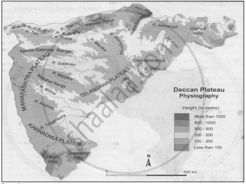
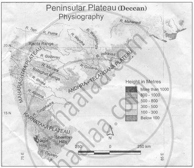
B) Deccan Plateau:
- The major portion of India's plateau is contained inside this physiographic category.
- This plateau has a roughly triangular shape.
- The line connecting Rajmahal Hills and Kanyakumari, which cuts across the Eastern Ghats, designates one of the triangle's sides.
- The Rajmahal Hills, Mahadeo Hills, Maikal Range, and Satpura Range identify the second arm.
- The Western Ghats distinguish the third arm.
- This Plateau is approximately 7 lakh square km in size and rises between 500 and 1000 m above sea level.
1) The Western Ghats
- The Peninsular Plateau is bounded on the west by the Western Ghats.
- It runs parallel to the coast of the Arabian Sea.
- The northern part of this range is called as Sahyadris.
- The Sahyadris rise in elevation from north to south.
- Anaimudi is located at the tri-junction of the Anaimalai Range, the Cardamom Hills, and the Palani Hills.
- Kodaikanal is a lovely hill resort located on the Palani Hills.
2) The Eastern Ghats
- This Plateau's eastern border is formed by the Eastern Ghats, which extend from southwest to northeast. This range is also called as Poorvadri.
- The Nilgiri Hills connect the Eastern and Western Ghats and are located on the boundary of Tamil Nadu and Karnataka.
- Compared to the Western Ghats, the Eastern Ghats are not as continuous.
- There are various spots in this mountain where the rivers Mahanadi, Godavari, Krishna, Pennar, and Kaveri have cut through.
Example
On the basis of Fig, answer the following questions:

- In which direction does the region with an altitude of more than 6000m lie in India ?
- Look for the south-flowing river in the peninsular region. In which river basin does it lie?
- In which direction is the slope of the region in the north shown in dark green?
- Make a list of plateaus located in between Aravali ranges and Chhota Nagpur Plateau.
- Name the peak shown in the Eastern Ghats
- Which mountains demarcate the deep plains of Brahmaputra?
- In which direction does the height of the Sahyadri hills increase?
- The Vindhyas act as water divide between which two river basins?
- In which direction do the Aravalis lie?
- Aravali ranges act as a water divide between which rivers?
- Name the hills located on the plateaus to the east of Aravalis.
- Across which states have the Deccan Plateau spread?
- Give the relative location of the Nilgiri Hills.
- Which hill ranges lie to the west of the Deccan Plateau?
- Enumerate the characteristics of the Western Ghats.
- Compare the Eastern and the Western Ghats.
- Why are the Western Ghats called a water divide?
- The region with an altitude of more than 6000m lies part of India towards the north and north eastern.
- River Wardha and Vainganga are the south flowing river in the peninsular region. These lie in the Godavari river basin.
- The region in the north shown in dark green is the North Indian Plain. It slopes towards the east.
- Plateaus located in between Aravalli ranges and Chhota Nagpur Plateau are Mewad Plateau, Bundelkhand, Baghelkhand and Malwa Plateau.
- Mahendragiri (1600m) and Malayagiri (1187m) are the peak shown in the Eastern Ghats.
-
Dafla Hills, Naga Hills, Garo, Khasi and Jaintia Hills demarcate the deep plains of Brahmaputra.
- Nilgiri Hills lie at the convergence of Western Ghats and Eastern Ghats in the southern part of the Deccan Pleateau.
- The height of Sahayadri hills increase towards the south.
- The Vindhyas acts as a water divide between Ganga river system and Narmada river system.
- The Aravallis lie in the northwestern direction.
- The Aravallis act as a water divide between the Narmada and Ganga rivers.
- The hills located on the plateau to the east of Aravalis are Rajasthan Alwar range.
- The Deccan plateau is spread across the states of Telangana, Maharashtra, Tamil Nadu, Karnataka, Kerala and Andhra Pradesh.
- The Western Ghats, also called the Sahyadri, are a north-south chain of mountains or hills that mark the western edge of the Deccan plateau region.
- The characteristics of the Western Ghats are-
- They rise steeply from the west coast, and originate from the Tapti river, till Kanyakumari.
- They are higher than the Eastern Ghats, and have an average height of 900 to 1100 m, the highest peak being Anai Mudi.
- The hills are continuous with an average width of 50 to 80 metres.
- Many important rivers of the Deccan plateau originate from these ghats.
- They lie perpendicular to the southwest monsoon winds, causing heavy rainfall on their windward side.
16.
| EASTERN GHATS | WESTERN GHATS |
| The mark the eastern edge of Deccan plateau. | The mark the western edge of Deccan plateau. |
| They are broad. | They are very narrow. |
| They receive less rainfall. | They receive more rainfall. |
| They are discontinuous and irregular. | They are continuous and regular, hence they possess higher elevation |
| The Highest peak is Mahindra Giri. | The highest peaks are Anai Mudi and Dodda Beta. |
17. The western ghats are the highest boundary line of many Peninsula and Konkan rivers. It divides basins of the east-flowing Peninsular river from those of Konkan and Malabar river which are west-flowing rivers. Hence, western ghats are major water divides of peninsular India.
If you would like to contribute notes or other learning material, please submit them using the button below.