Topics
Our Earth and Our Solar System
Motions of the Earth
The Earth and Its Living World
Environmental Balance
Family Values
Rules Are for Everyone
Let Us Solve Our Own Problems
Public Facilities and My School
Maps - Our Companions
Getting to Know India
Our Home and Environment
Food for All
Methods of Preserving Food
Transport
Communication and Mass Media
Water
Clothes - Our Necessity
The Environment and Us
- Deforestation and Its Causes
- Consequences of Deforestation
- Pollution and Its Types
- Water Pollution and Its Causes
- Air Pollution and Its Causes
- Soil Pollution and its Causes
- Environmental Balance
- Our Needs and the Environment
- Global Efforts for Protection of the Environment
- Efforts to Maintain Biodiversity
- Devrais - a Boon for All Living Creatures!
Constituents of Food
Our Emotional World
Busy at Work - Our Internal Organs
Growth and Personality Development
Infectious Diseases and How to Prevent Them
Substances, Objects and Energy
Community Health and Hygiene
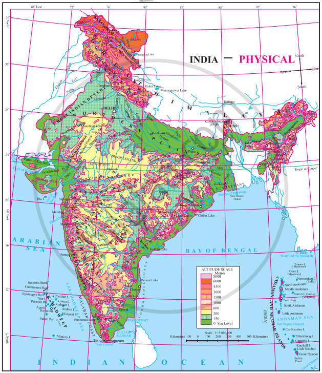
Physical Map of India:
- Indian Peninsula: India is surrounded by water on three sides: the Arabian Sea to the west, the Bay of Bengal to the east, and the Indian Ocean to the south. The southern part of India is called the Indian Peninsula because it is surrounded by water on three sides.
- Himalayas: The northern border of India has very tall mountains called the Himalayas. These mountains are the highest in the world and are covered with snow.
- Geography: India has many different types of land, including mountains, plains (flat lands), plateaus (high flat lands), deserts, and forests. The height of the land changes a lot, from flat plains to high mountains over 8,000 meters above sea level.
- Climate and vegetation: Because the land is so different in height and type, the weather also changes from place to place. This means that different parts of India have different plants, animals, and birds.
- Crops: Wheat is mainly grown in the north of India, where the land is flat and fertile. Rice is mostly grown in the south and along the coast, where there is plenty of water. Jowar (a type of grain) is commonly grown in Central India.
- Diversity: India has many different people who belong to different castes, tribes, and religions. People in different parts of India speak many different languages. There are also many differences in food, clothing, and festivals depending on where you are in the country.
- Culture: The variety in the land, weather, and crops means that people in different parts of India live in different ways, with unique customs, traditions, and cultures.

If you would like to contribute notes or other learning material, please submit them using the button below.
