Topics
Our Earth and Our Solar System
Motions of the Earth
The Earth and Its Living World
Environmental Balance
Family Values
Rules Are for Everyone
Let Us Solve Our Own Problems
Public Facilities and My School
Maps - Our Companions
Getting to Know India
Our Home and Environment
Food for All
Methods of Preserving Food
Transport
Communication and Mass Media
Water
Clothes - Our Necessity
The Environment and Us
- Deforestation and Its Causes
- Consequences of Deforestation
- Pollution and Its Types
- Water Pollution and Its Causes
- Air Pollution and Its Causes
- Soil Pollution and its Causes
- Environmental Balance
- Our Needs and the Environment
- Global Efforts for Protection of the Environment
- Efforts to Maintain Biodiversity
- Devrais - a Boon for All Living Creatures!
Constituents of Food
Our Emotional World
Busy at Work - Our Internal Organs
Growth and Personality Development
Infectious Diseases and How to Prevent Them
Substances, Objects and Energy
Community Health and Hygiene
Techniques for Representing Landform Elevation on Maps:
Landforms: Easy to show length and width on paper. Difficult to show height and depth. There are different methods of showing the elevation or height of the land:
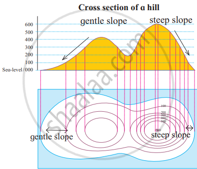
(1) Contour line method
- This method is used to show the unevenness of landforms on a map. The height of the land is measured from sea level. Next, points of the same height are identified.
- Their position is marked accurately on the map. These locations are joined with a line. Such lines are called contour lines.

Contour line method
(2) Layer tinting method
- This method is based on contour lines. In this method, the spaces between contour lines are filled with colour. Each colour indicates a specific height.
- For example, water bodies are coloured blue, whereas the adjoining land is coloured dark green. Land higher than that is coloured a light green, next higher land is coloured yellow, and so on.
(3) Digital elevation model
- This is the most modern method. In this, the information obtained through man-made satellites is presented with the help of computers.
- Using computers, we can even find the height of each point on a digital map.
- Physical maps can be used in military operations, tourism, drawing up mountaineering routes, in making regional development plans, etc.
If you would like to contribute notes or other learning material, please submit them using the button below.
